By Jean Baptiste Ndabananiye
Inside Rwanda’s high-stakes battle to stop erosion and landslides before they bury more than just land. A terrifying sight— in a hill of Rubengera in Karongi District where terraces lace the green slopes and farmers rise early to coax life from the land— yawns open: a landslide nearly 50 meters deep in some points— proof that even strong land management efforts can be overwhelmed by relentless force of nature.
Not more than three districts away from here, specifically in Cyome of Gatumba Sector in Ngororero, houses once tiled with pride are being demolished by their owners, not by neglect but by a disaster instigated by human-induced erosion. There, erosion is not abstract—it steals cooked meals from restaurant kitchens, crushes livelihoods under collapsed walls, and buries a vibrant market in silence.
This is no scattered phenomenon. According to the 2022 State of Soil Erosion Control in Rwanda report by the Rwanda Water Resources Board (RWB) and the International Union for Conservation of Nature (IUCN), nearly half of Rwanda’s land—over one million hectares—stands at risk of erosion, with dire implications for food security, infrastructure, and economic resilience. The nation loses up to 5.5% of its GDP (gross domestic product) annually to soil degradation— an environmental and economic crisis that requires a bold, 514 billion Rwandan franc intervention— about the net financial requirement of 42 billion RWF annually over eight years— to staunch its flow, according to the report.
This article embarks on an urgent journey through the most affected districts—from an erosion-affected dam of a marshland in Muhanga to a flood-ravaged streambed of Ngororero, to expose the scale of the crisis, the progress accomplished since the report’s release, and amplify the voices of those battling erosion’s wrath daily. As erosion undermines both land and lives, the question looms: will Rwanda act decisively before more ground—literal and economic—is lost? This article delves into this complex and urgent issue, while highlighting—among others— the importance of coordinated action and sustainable land management practices to safeguard the country’s agricultural productivity and economic stability.
Status of erosion in the most affected districts of Rwanda
“Erosion steals from my neighbor and my community. It impoverishes everyone. A food and farm system that encourages erosion is a direct assault on our neighbors and a direct assault on God’s equity,” ― Joel Salatin, The Marvelous Pigness of Pigs. To comprehend this situation, we are going to get to different places experiencing this problem.
Karongi
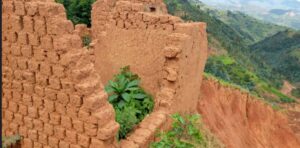
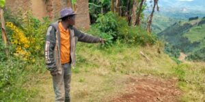
On 9 May 2025, Life In Humanity is in Bigugu Village in Nyarugenge Cell, Rubengera Sector in Karongi where we are starting. Here, we visit this almost 50-meter-deep landslide which yawns open and is extremely frightening. This landslide, though a result of an uncontrollable natural force, illustrates the colossal importance of comprehensive land protection. If the Government of Rwanda manages to safeguard all of the country’s terrain, it will be an extremely commendable accomplishment—one that enhances resilience even against nature’s most unpredictable events.
According to some residents of this locality, this area used to bear terraces and not to be steep—conditions usually associated with erosion control. However, the land has still collapsed, revealing that that erosion mitigation can sometimes fail due to deeper underlying issues.
Frédérick Habarurema in Bigugu is one of the residents. He says “This land burst in July, triggering this landslide. It was at around 9h00 when we immediately saw a certain part of the hill explode. As no rain falls during that season, it wasn’t then raining too. We don’t actually know what caused this landslide. Even more puzzling, and as you can even notice it, this hill carries radical terraces, and the part which collapsed was also protected by radical terraces.
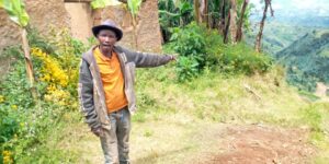
Before this landslide occurred, this area didn’t experience erosion, it’s the landslide itself that transformed the area into a frightening erosion zone. Previously, this place constituted a beautiful plateau whose summit where people lived. Tragically, ten houses belonging to ten families were buried in the disaster.”
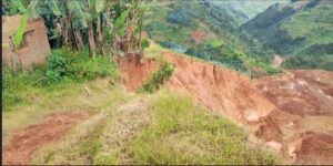
Residents narrowly escaped death thanks to early warning signs and timely government intervention after a massive landslide began threatening their village. “Fortunately, it has killed nobody, since before the landslide occurred, people noticed signs of cracks; the land first descended a bit from its original level, and it could even take a week, for the slightly split part to collapse. After the residents saw it, the government came to relocate us from here to another place. We are 48 households moved from here to the other part where the government is renting us residential houses.
The landslide didn’t happen on one day; even now in this particular place where we are standing now can experience a landslide. But before collapsing, it first cracks as a warning sign, and passes around three days for it to burst, the reason why no person and no livestock have died. At the very beginning when the hill faced a landslide, we thought that it was a minor situation, but at one time the hill’s movement became so severe that some buildings were swept away. That’s when we realized that the situation was worsening more considerably than we thought, and the government instantaneously intervened to relocate us.”
Habarurema explains losses sustained from this calamity. “Eh, eh, we’ve suffered huge losses! I had just renovated these houses. I had recently roofed this building with iron sheets and finished plastering it with mortar (cement and sand)—only for it to start sinking out of my hands before I even got to use it. There’s also a heap of sand I was going to use to make a concrete floor for my house. That house with the tiled roof also belongs to me. If this disaster hadn’t happened, I’d be telling you that I wouldn’t sell these buildings for anything less than 7,000,000 RWF [around $5,000]. And even that price couldn’t reflect their full value, since they also featured kitchens and annexes.”
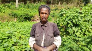
Béatrice Mukantaganda is another resident moved from this village. She says “We don’t know what has created the landslide, because it was in a sunny season and we just saw the hill burst. The landslide has engendered the loss of 6 500 000RWF to me. The worth of the land which was carried away equaled 1 000 000RWF, while crops namely carrots, peppercorn, cassava and sweet potatoes that it contained matched around 500 000RWF. This building still standing but which we have lost to the landslide and even this one destroyed to rubble carried the value of 5 000 000RWF.
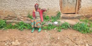
I and my husband are still both alive, forming a family of 10 people— with 9 children including three ones already married. We would like the government to intervene to protect the remaining part, lest it may develop into such erosion. We propose erosion-addressing mechanisms to be implemented.”
Not only the citizens in Bigugu fail to fathom reasons behind this landslide in a place which was protected by terraces, among others, but also we do. We are left searching for answers to this puzzle. Upon observing the landslide, we’ve speculated that it might have been triggered by the land’s fragility worsened by terraces that allowed rainwater to penetrate deeper into the soil, weakening it further and making it more prone to collapse.
However, Dr. Laure Rurangwa from the Rwanda Forest Authority (RFA) dismisses this explanation, noting that such landslides are not though surprising in this region. “A recent study has indicated that this landslide has been caused by the same deep‑earth movements— occurring inside the Earth— responsible for earthquakes and volcanic eruptions. Moreover, as you know it, that region frequently faces seismic activity, thanks to its proximity to Lake Kivu, so it is not astonishing for such an issue to occur there.”
Ngororero
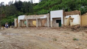
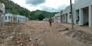
Always on the same mission to understand the situation, on the following day—10 May 2025— we reach Cyome in Gatumba Sector in Ngororero. On this day in Cyome, we should be struggling to find a way through the crowds— a vibrant market used to happen today here at Cyome. But, instead of the bustling market that once characterized this day in this particular locality, we now hear only the clanging of hammers and the sound of collapsing walls. Residents are dismantling their buildings due to “illegal mining-induced erosion.” The area is eerily quiet.
Residents of Cyome in Gatumba Sector are grappling with devastating erosion linked to illegal mining activities that followed the exit of a licensed investor, leading to destroyed infrastructure, lost livelihoods, and unpayable loans. Emmanuel Ndayisaba and Béatrice Mukankundiye are among those hardest hit, having invested heavily in buildings and business respectively now reduced to ruin. Ndayisaba points out “We have suffered huge losses that some of us will be unable to repay the loans.”
Mukankundiye says “The erosion washed away meat that I’d just cooked, carrots, tomatoes, and utensils like plates, spoons and forks as well as 50 kilograms of Irish potatoes since I was then running a restaurant here in Cyome. I’ve gotten a bank loan of 500 000RWF. I have not cleared it yet, I am doing it slowly and when they ask me why I am not repaying well, I reply to them that that the business has been severely hampered. I received the loan not below 6 months ago and I could have fully settled it, if we hadn’t experienced this erosion.”
This is yet another compelling case proving the danger of erosion, and also proving the urgent need for sustainable land and resource management. For a deeper look into how mining-triggered erosion has reshaped this community (Cyome) and the lives it once sustained as well as the district’s action against illegal mining, read the full story here.
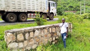
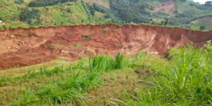
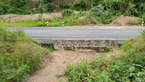
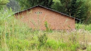
Because of erosion, water drainage systems such as culverts around this place (Cyome) have been blocked by sediment deposits. We have just identified three obstructed culverts, located at a short distance from Cyome, as some of them are shown in these photos below.
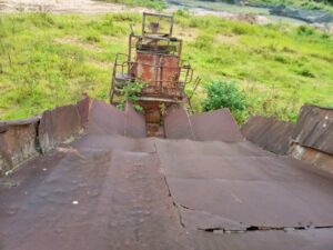
At approximately 500 meters from Gatumba shopping center, we also pinpoint a site that once served as a ground for crushing stones used in road construction. This is proven by the presence of a crushing machine and a house—now unreachable due to heavy sediment deposits—that was connected to the operation.
Muhanga
From Ngororero, we instantaneously head to Muhanga specifically in Rugeramigozi marsh where we conclude our mission on the field.
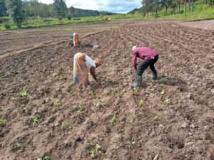
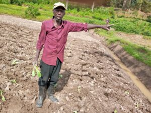
Here, we find some individuals planting cabbages in a portion of the marsh. This part of the swamp where we are has now been prepared to grow beans. However, before, these crops were not cultivated in this wetland—it was farmed with rice.
François Muhanda is one of those we meet in Rugeramigozi. He says “They have stopped us from cultivating rice, explaining that they first need to remove sediments that have accumulated in the dam. Because of the sediments in the dam, rice plantations lack water needed to thrive. Though I cannot be able to specify or estimate it, rice is more profitable and productive than farming the crops that we cultivate now. We are now working for Sisters in this place.”
Clémentine Nyirahabimana echoes it, saying “For us to quit farming rice, it was because water to irrigate the marsh had lacked, they then told us that they were going to eliminate the sediments from the dam. They then told us to farm beans. After the beans, they told us to cultivate maize. After the maize, we will farm beans again. We are now growing these cabbages on the Sister’s request to the president [of a cooperative exploiting this marsh], so she can get vegetables to feed the students.
Rice is more productive and beneficial because, when farmers harvested it, they used to deliver it to the cooperative, where they received cash to meet various needs, while also being given a portion of the rice for home consumption—unlike beans which people simply take home and consume.”
According to an undated story by the paper, Umuseke, the dam will cost more than 800 million RWF, to be developed again. This newspaper has cited Muhanga’s Mayor Jacqueline Kayitare, as saying “We conducted a feasibility study and found that a budget of over 800 million Rwandan francs is needed to address the sediment issue.”
On some of the sides of the dam, we see trees which should be protecting the dam from erosion. But Nyirahabimana explains “The dam has been affected by sediments from different hills; yes, the dam is surrounded by some trees on some of its sides, and if there weren’t these forests, it would be filled for one day.
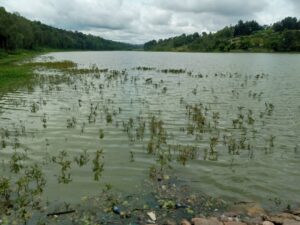
We wish it to be cleared of the sediments, and the residents around it should keep trenches unblocked, to channel rainwaters away. Every time that they are blocked by sediment deposits, people should clear them again immediately. Agroforestry should also be used.”
The Mayor Kayitare agrees with her on reasons for the sediments in the dam. As we have read it in Umuseke, this mayor has said “ All soil and sediments from these hills overlooking Rugeramigozi flow down into the dam and accumulate.”
Soil erosion is the process by which the upper layer of soil, which is the most fertile and crucial for plant growth, is removed by natural forces such as water, wind, or human activity. It leads to the loss of nutrients, reduced agricultural productivity, sedimentation in waterways, and degradation of land quality. The Cambridge Dictionary defines erosion as a process in which soil, stone, and so on is gradually damaged and removed by waves, rain, or wind, or the result of this action. FAO (2020) defines soil erosion as the accelerated removal of topsoil from the land surface through water, wind and tillage.
Impacts of soil erosion include loss of fertile top soil, reduced crop yields, increased pollution and sedimentation in rivers and lakes, desertification in extreme cases. So, a place which no longer possesses its topsoil because of a landslide, is erosion— the aftermath where the area is now eroded. The resulting state — bare, degraded, stripped of fertile topsoil — is indeed erosion, even if the event that has triggered it is a landslide. So, this place yawning open is erosion—the result of the landslide.
The top 3 most severely affected districts—according to the report— include Ngororero, with 58,003 hectares—85% of its land—at high erosion risk, Muhanga, with 53,352 hectares—82% of its area—under threat, and Rutsiro, where 48,143 hectares—73% of the district’s land—are erosion-prone. Other districts like Karongi, Gakenke, Huye, Nyaruguru, Rulindo and Nyamagabe need considerable attention as the risk accounts for more than 60% of the district land. For example, 57,187 hectares, of land which matches about 72% of the total district land in Karongi, lie at risk of erosion— with 5,313 at extremely high risk, 11,169 at very high risk, 18,330 at high risk and 22,374 at moderate risk.
Nationwide situation of erosion
The May 2022 State of Soil Erosion Control in Rwanda report contains alarming figures and a stark warning: soil erosion represents Rwanda’s most severe environmental threat, particularly in the nation’s several landscapes. It emphasizes that erosion forms both a driver and a symptom of broader land degradation—exacerbated by improper land use, declining vegetation cover, challenging topography, fragile soils, and changing climate patterns.
Mapping data from the report show that out of Rwanda’s 30 districts, approximately 1,080,168 hectares—45% of national land—face high erosion risk. The following is the breakdown of the data:
- 71,941 hectares (7%) are at extremely high risk
- 190,433 hectares (18%) at very high risk
- 300,805 hectares (28%) at high risk
- 516,999 hectares (48%) at moderate risk
Within the catchment aspect, the upper Nyabarongo is the worst affected with 45,961 hectares of which 28,123 hectares are harmed by rill erosion, 14,337 hectares are affected by gullies, 2,353 hectares are affected by severe gullies, while 1,148 hectares are damaged by landslides. Kivu catchment area follows with 34,050 hectares affected of which 15,085 hectares are affected by rill erosion, 16,033 hectares are harmed by gullies, 2,426 hectares are affected by severe gullies and 506 hectares marred by landslides.
Exactly three years later, what has now happened?

Different actors are working to restore and secure the fragile lands of Rwanda, through a multi-stakeholder approach combining reforestation, terracing, farmer education, and innovative erosion control strategies.
“To stabilize the slopes in this area [where the landslide has occurred], we’ve planted deep‑rooting tree species known to reinforce both soil and vegetation—but deliberately starting at least twenty meters away from the landslide scar to minimize risk. Next, we plan to establish a forest across the Ndaba basin,” says Dr. Rurangwa who manages the Congo-Nile Divide Project— launched at the end of the last year— which will close in 2029. This “Ambitious Congo-Nile Divide Restoration” project, according to Dr. Rurangwa, is being implemented in 8 districts including Ngororero, Karongi, Rutsiro, Nyamagabe, Rusizi, and Nyabihu, among others. “The project is being carried out in all Congo Nile districts except Rubavu and Musanze.” The project entatils planting a diverse array of tree species, involving indigenous and agroforestry trees in that region.
Dr. Rurangwa adds “Under a long‑term management plan, that basin [including the place where the landslide has happened] will be zoned for a mixed system of a forest and perennial crop— one portion dedicated to tea cultivation and the other to protective tree plantations. Seasonal crops tend to weaken soil structure, so replacing them with perennial crops and a forest will help to secure the land. This strategy also aligns with the relocation of residents from hazardous areas, reserving the former landslide zone exclusively for reforestation and a tea plantation, as recommended in an official report. ”
Christophe Nkusi, Ngororero District’s Mayor explains what the district is implementing to deal with erosion. “Fighting and preventing erosion involves continuously educating farmers on how to safeguard their land. We teach them to dig trenches and plant grass for livestock, which also strengthens the soil and prevents erosion. As a district, we have a budget allocated to terracing, and various stakeholders support us in this effort to increase both radical and naturally formed terraces. This intervention helps combat erosion, because—as you know—land protected by terraces does not easily succumb to erosion, and fertilizers are better retained in the soil.
If you need the exact number of hectares we have protected since the May 2022 report, I can provide that information later, as I don’t have it on hand now. However, we are carrying out holistic work to safeguard the land in our district—this includes radical terracing, natural terracing, tree planting, fruit tree cultivation, and forest development. We also expect several upcoming projects aimed at addressing erosion-related issues. Concerning water drainage systems that are blocked due to erosion, we organize special community works to unblock them—especially during this rainy season and considering that our district is mountainous. We closely monitor this, and if you return to those areas now, you will find that we’ve already cleared the gutters and culverts.”
As aforesaid, fighting and preventing erosion requires coordinated action. Imbaraga Farmers Organization contends that it has to stand at the forefront. This national nongovernmental organization represents more than 32,000 farmers in every Rwandan district except the three districts of Kigali City where farming stands minimal, according to its Legal Representative, Jean Paul Munyakazi.
Far from being a passive observer, the organization affirms its readiness to play an active role. Munyakazi says “Erosion occurs not only in Rwanda, it represents a global challenge exacerbated by climate change, and its impacts are felt most acutely by farmers, though climate change negatively affects all the population of the world. In response, Imbaraga Farmers Organization is tackling the problem through four key strategies.
Soil‑conservation practices— we are introducing low‑disturbance methods, soil‑friendly cultivation practices which just involve surface clearing or sod [the surface of the earth, with the grass and roots that are growing in it] stripping, rather than ploughing or digging the soil; which compromises the soil structure and renders soil more fragile. Compost promotion—we are encouraging widespread use of compost. Though most people don’t understand its weight, compost is invaluable in protecting the environment and decreasing erosion.”
He adds “We have planted forests in Nyaruguru, Kayonza, and Nyamagabe districts to provide nectar sources for bees and to anchor soils with deep tree roots. Lastly, we are rolling out and promoting biogas technology in six districts to cut firewood demand, preserve tree cover, and indirectly protect slopes from deforestation‑induced erosion. Farmers must hold the lead in these efforts—our goal being for them to contribute at least 60 percent of the action needed to secure Rwanda’s soils.”
Rwanda Water Resources Board (RWB), a key co-producer of the national erosion risk report, offers a striking perspective on how far the country has come. RWB indicates that the horizon ahead is equally promising. RWB has told Life In Humanity “In 2019 surveys using Remote sensing were identifying only 282,352 hectares (26% of the at-risk land) are currently protected against erosion.”
It has added “In 2024, RWB was estimating the restoration efforts to 332,861 hectares mainly through the additional contribution in the recent years of Green Gicumbi – Strengthening Climate Resilience of Rural Communities in Northern Rwanda (Green Gicumbi Project); Green Amayaga – Green Amayaga Project: Landscape Restoration and Climate Resilience in the Amayaga Region; CDAT – Commercialization and De-risking for Agricultural Transformation Project; Hinga Weze – Feed the Future Rwanda Hinga Weze Activity; KIIWP – Kayonza Irrigation and Integrated Watershed Management Project; TREPA – Transforming Eastern Province Through Adaptation (TREPA); COMBIO Weze – Community Biodiversity and Livelihood Enhancement Project (COMBIO Weze); IWRM – Integrated Water Resources Management Program.
Currently, a new initiative in the Volcano region and Vunga Corridor; Mwogo catchment; Intego Facility of Rwanda Green Fund; and other related institutions are expected to double this achievement by 2029.”
Forests, in particular, have emerged as natural fortresses against erosion. Their role in stabilizing fragile terrain is clearly evidenced in the May 2022 erosion risk report which states “The least district susceptible to erosion is Rusizi, where only 20% of its district land is at risk, about 18,212 hectares. The contribution of forests in protecting fragile land in Western Province is evident, particularly the Nyungwe National park in Rusizi and Nyamasheke districts as well as forest plantations in steep slopes in highlands of Western Province.”
Soil erosion across the world
The United Nations Office for Disaster Risk Reduction in its story titled “Soil erosion” states that a total of 75 billion tons of fertile soil is removed every year from the global soilscape by erosion. “As a result, precious soil resources, which should be preserved for future generations, are continuously reduced. Every year approximately 12 million ha of land are lost (FAO and IAEA, 2017).
Because 95% of the food consumed globally comes from the soil, soil erosion mitigation through the application of sustainable soil management is critical for protecting soil while ensuring a sustainable and food secure world (FAO, 2020). Sustainable soil management is an integral part of sustainable land management, as well as a basis for addressing poverty eradication, agricultural and rural development, promoting food security and improving nutrition.”
EU Science Hub highlights “A key threat to land degradation worldwide, soil loss by water erosion could grow by up to 66% over the period 2015-2070. The global soil erosion rate is projected to increase by 30% to 66% over the period 2015–2070 under three alternative climate-economic scenarios, according to a JRC study. The current impact of soil erosion on agricultural productivity at global scale has been estimated at about USD 8 billion.”
World Wildlife Fund says “Given the amount of deforestation around the world, zero net deforestation may seem unattainable. However, it is not only possible, but necessary if we intend to preserve our most precious wildlife, respect and empower local communities, maintain critical ecosystem services and reduce greenhouse gas emissions. Some nations are already finding success. Paraguay reduced the rate of deforestation in their country by 85% in the years just following enactment of its 2004 Zero Deforestation Law.”
Call to action
As Rwanda faces one of its most urgent environmental threats, the stories from Karongi, Ngororero, and Muhanga are not merely cautionary tales—they are urgent calls for united action. Let these accounts stir decision-makers, citizens, institutions, and global partners alike.
The soil beneath our feet may be eroding, but our resolve must not. The time to replicate sustainable land management, strictly enforce mining regulations, restore damaged ecosystems, and fund community resilience is now. If we act boldly and decisively—grounded in data, driven by local voices, and guided by national commitment—we will not only preserve our land, but protect livelihoods, safeguard our future, and honor the resilience of those standing on the frontline of erosion. The cost of delay is loss. The reward of action is stability, dignity, and growth. Let us choose action. Let us secure the land—before more than land is lost.
As soil erosion is not just Rwanda’s fight—instead constituting a defining global challenge of our time, with 75 billion tons of fertile soil vanishing every year, the planet’s ability to nourish future generations is slipping away. This crisis transcends borders and politics—it threatens food security, climate stability, economic livelihoods, and human dignity worldwide.
What’s needed now is unwavering commitment—from global institutions to national governments, from researchers to rural farmers, from local journalists to international partners. We must embrace sustainable soil and land management as the cornerstone of resilience and equity. We must prioritize restoration over extraction, protection over indifference, and cooperation over delay.
Let this be the moment we choose stewardship. Let this be the generation that holds the soil and the future together.
Life In Humanity extends its heartfelt appreciation to Rwanda Environmental Journalists (REJ) and the FOJO Media Institute for their invaluable support in enabling the production of this article. Their commitment to empowering environmental journalism continues to create a profound difference in raising awareness and inspiring action.
Cool partnership https://shorturl.fm/XIZGD
We appreciate the feedback.
Awesome https://shorturl.fm/5JO3e
We appreciate this highly uplifting support!
Super https://shorturl.fm/6539m
We are excited to get this very inspiring feedback!